Have you ever wondered what your house looks like from above? Maybe you’re curious about how your neighborhood has changed over time, or you want to see your home from a unique perspective. Whatever your reason, viewing your house from satellite is easier than you might think.
What is Satellite Imagery?

Before we get into the specifics of viewing your house, let’s take a moment to understand what satellite imagery is and how it works.
Definition of Satellite Imagery
Satellite imagery refers to photographs of the Earth’s surface taken by satellites orbiting our planet. These images provide a bird’s-eye view of our world, capturing everything from sprawling cities to remote wilderness areas.
How Satellites Capture Images of Earth
Satellites equipped with powerful cameras and sensors orbit the Earth at various altitudes, continuously capturing images of the planet below. These satellites can be operated by government agencies, such as NASA, or by private companies. As they pass over different regions, they snap high-resolution photos that are then transmitted back to Earth.
Types of Satellite Images Available for Public Viewing
There are several types of satellite images available for public viewing, each with its own unique characteristics:
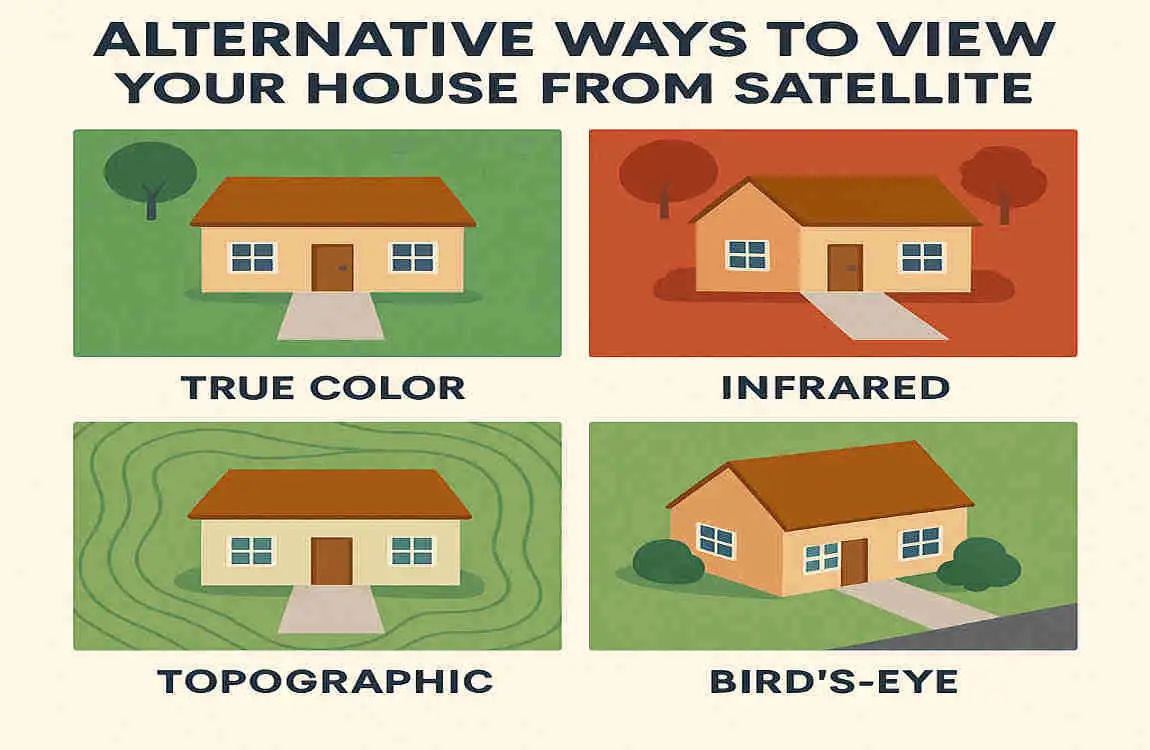
- Optical imagery: The most common type of satellite imagery, resembling photographs taken from above. They show the Earth’s surface in visible light, just as our eyes would see it.
- Infrared imagery: These images capture the heat emitted by objects on Earth’s surface, which can help study vegetation, water temperatures, and more.
- Radar imagery: Radar satellites can penetrate clouds and darkness, making them useful for monitoring weather patterns and tracking changes in the Earth’s surface over time.
Now that we have a basic understanding of satellite imagery, let’s explore the popular platforms you can use to view your house from above.
Popular Platforms to View Your House from Satellite
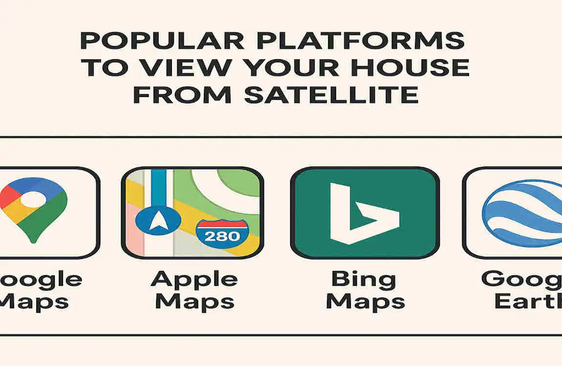
Several user-friendly platforms let you easily view your house from satellite. Let’s take a closer look at some of the most popular options.
Google Earth: Features and Capabilities
Google Earth is one of the most well-known and widely used platforms for viewing satellite imagery. It offers a wealth of features that make it easy to explore your home and neighborhood from above:
- High-resolution imagery: Google Earth provides detailed satellite images of many areas around the world, allowing you to zoom in and see your house up close.
- 3D view: Switch to 3D to see your home and surroundings from different angles, for a more immersive experience.
- Historical imagery: Google Earth lets you view historical satellite images, so you can see how your area has changed over time.
- Street View integration: In some areas, you can seamlessly transition from satellite view to street-level imagery, giving you a complete picture of your neighborhood.
Google Maps Satellite View
If you’re already familiar with Google Maps, you’ll be happy to know it also offers a satellite view. While not as feature-rich as Google Earth, Google Maps’ satellite view is a quick way to check out your house from above.
Other Satellite Image Services like Zoom Earth
In addition to Google’s offerings, there are other satellite image services you can use to view your home. One popular alternative is Zoom Earth, which provides near-real-time satellite imagery of Earth’s surface.
Differences Between These Platforms
While all of these platforms allow you to view your house from satellite, there are some key differences to keep in mind:
Platform Resolution Real-time Imagery 3D View Historical Imagery
Google Earth High No Yes Yes
Google Maps Medium No No No
Zoom Earth Medium Yes No No
Now that we’ve covered the popular platforms, let’s dive into a step-by-step guide for using Google Earth to view your house from satellite.
Step-by-Step Guide to View Your House on Google Earth
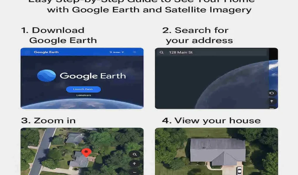
In this section, we’ll walk you through the process of using Google Earth to view your house from satellite. Follow these simple steps to see your home from above.
How to Download and install Google Earth Pro
First, you’ll need to download and install Google Earth Pro on your computer. Here’s how:
- Visit the Google Earth website and click on the “Download” button.
- Select your operating system (Windows, Mac, or Linux) and click on the appropriate download link.
- Once the download is complete, open the installer file and follow the on-screen instructions to install Google Earth Pro on your computer.
How to Open and Use Google Earth on Desktop and Mobile
After installing Google Earth Pro on your computer, you can open it by double-clicking on the desktop icon or searching for it in your start menu. If you prefer to use Google Earth on your mobile device, you can download the app from the App Store or Google Play Store.
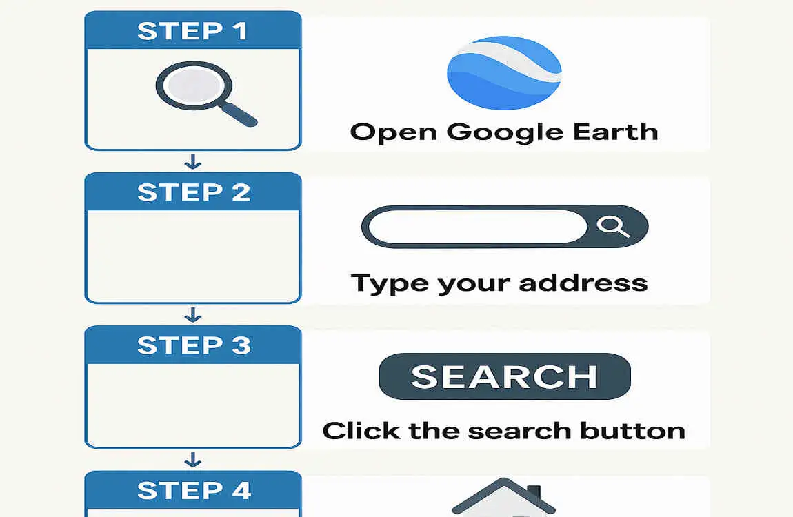
Searching for Your Address in Google Earth
Once you have Google Earth open, you can start by searching for your address:
- In the search bar at the top of the screen, type in your full address, including your street number, street name, city, and state/province.
- Press Enter or click on the magnifying glass icon to initiate the search.
- Google Earth will zoom in on your location and display a satellite view of your neighborhood.
Zooming in and Using the Zoom Slider Effectively
To get a closer look at your house, zoom in on the satellite image. Here’s how to do it effectively:
- Use the zoom slider: On the right side of the screen, you’ll find it. Click and drag the slider up to zoom in, or down to zoom out.
- Use your mouse wheel: If you’re using a mouse, you can also zoom in and out by scrolling your mouse wheel.
- Double-click to zoom: For a quick way to zoom in on a specific area, double-click on the spot you want to focus on.
Navigating with Mouse Controls (Panning, Zooming, and 3D View)
Google Earth offers intuitive mouse controls that make it easy to navigate the satellite imagery:
- Panning: To move the view around, click and drag your mouse in any direction.
- Zooming: As mentioned earlier, you can zoom in and out using the zoom slider or your mouse wheel.
- 3D view: To switch to a 3D view of your area, hold down the Shift key and click and drag your mouse up or down. This will tilt the view, allowing you to see your house from different angles.
How to Spot Your House from Satellite Images and Check for Updates
Once you’ve zoomed in on your neighborhood, you should be able to spot your house in the satellite image. Look for familiar landmarks, like your driveway, pool, or nearby buildings, to help you identify your home.
If you want to check for updates to the satellite imagery, you can use the “Historical Imagery” feature in Google Earth. Here’s how:
- In the toolbar at the top of the screen, click on the clock icon to open the Historical Imagery slider.
- Drag the slider left or right to view satellite images from different dates.
- If you see a more recent image of your house, you can switch to that view by clicking on the “Show this image” button.
Tips for Better Viewing (Lighting, Angles, 3D Mode)
To get the most out of your satellite view experience, keep these tips in mind:
- Adjust the lighting: In the toolbar, click the sun icon to adjust the satellite image’s illumination. This can help you see details more clearly.
- Experiment with angles: Use the 3D view feature to tilt and rotate the satellite image for a better perspective on your house and neighborhood.
- Try different modes: Google Earth offers options like “Street View” and “Photo,” which can provide additional context and details about your area.
Now that you know how to view your house on Google Earth, let’s explore some alternative ways to see your home from satellite.
Alternative Ways to View Your House from Satellite
While Google Earth is a powerful tool for viewing your house from satellite, there are other methods you can use to get a different perspective on your home.
Using Google Maps Satellite View
If you don’t want to download and install Google Earth, you can still view your house from satellite using Google Maps. Here’s how:
- Open Google Maps in your web browser or on your mobile device.
- In the search bar, type in your full address and press Enter.
- Once the map zooms in on your location, click on the “Satellite” button in the bottom left corner of the screen.
- You’ll now see a satellite view of your neighborhood. Use the zoom controls to get a closer look at your house.
Utilizing Street View for Street-Level Imagery
In addition to satellite view, Google Maps also offers Street View, which provides street-level imagery of many areas. To use Street View to see your house:
- Follow the steps above to open Google Maps and find your address.
- Once you’re in satellite view, click and drag the yellow “Pegman” icon onto the street near your house.
- The view will switch to Street View, showing you a ground-level perspective of your home and neighborhood.
- Use the on-screen controls to navigate and explore the area around your house.
Using Zoom Earth for Near Real-Time Images
If you’re interested in seeing near-real-time satellite images of your house, you can use Zoom Earth. Here’s how:
- Visit the Zoom Earth website in your web browser.
- In the search bar at the top of the screen, type in your full address and press Enter.
- Zoom Earth will display a satellite image of your area, with the most recent available image shown by default.
- Use the zoom controls to get a closer look at your house. Keep in mind that the resolution may not be as high as Google Earth’s, but you’ll see a more up-to-date view.
How to Save or Capture Satellite Images for Personal Use
If you want to save a satellite image of your house for personal use, you can do so in Google Earth or Google Maps:
- Google Earth: Once you have the desired view of your house, go to “File” > “Save” > “Save Image.” Choose your preferred file format and location, and click “Save.”
- Google Maps: Right-click on the satellite image and select “Save image as.” Choose your preferred file format and location, and click “Save.”
Just remember to use these images for personal purposes only and to respect others’ privacy when sharing or posting them online.
Limitations of Satellite Views
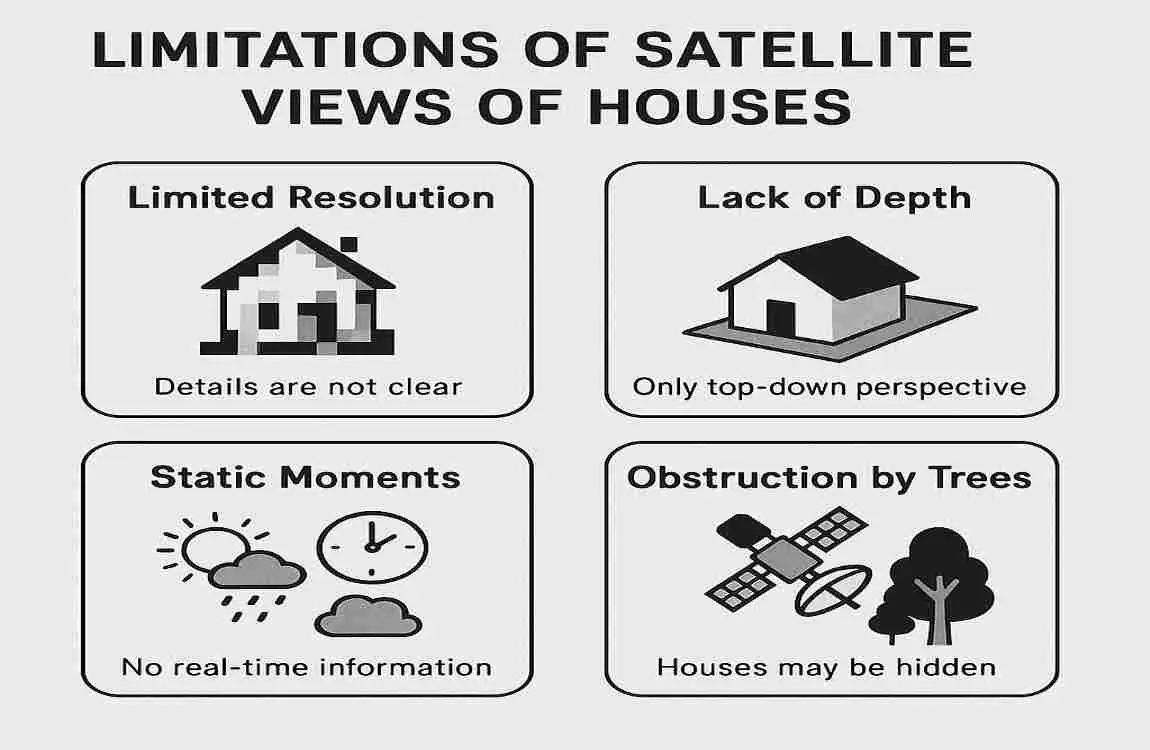
While satellite imagery can offer fascinating views of your house and neighborhood, it’s essential to understand its limitations.
Why Satellite Images Are Not Always Up-to-Date
One of the main limitations of satellite imagery is that it is not always up to date. Satellites pass over specific areas at regular intervals, but it can take time for the images to be processed and made available to the public. As a result, the satellite view you see may be several months or even years old.
Resolution and Privacy Limits
Another limitation to keep in mind is the resolution of satellite imagery. While some areas have high-resolution images that show fine details, others may have lower-resolution images that are less clear. Additionally, privacy restrictions are in place to protect individuals and their property, which may result in certain areas being blurred or obscured in satellite imagery.
No Real-Time Live Satellite Images for Most Users
If you’re hoping to see a live, real-time satellite view of your house, you’ll be disappointed. Most satellite imagery platforms, including Google Earth and Google Maps, do not provide live images. Instead, they offer the most recent available images, which may be several days or weeks old.
Satellite Imagery Coverage – Urban vs. Rural Differences
Finally, it’s worth noting that satellite imagery coverage can vary between urban and rural areas. Urban areas tend to have more frequent satellite passes and higher-resolution images, while rural areas may have less frequent coverage and lower-resolution images. This means that if you live in a rural location, you may not be able to see your house as clearly as someone living in a city.
Frequently Asked Questions (FAQs)
Can I See My House in Real Time from Space?
Unfortunately, most users cannot see their house in real-time from satellite. As mentioned earlier, satellite imagery platforms typically provide the most recent available images, which may be several days or weeks old. Real-time satellite imagery is generally reserved for government and military use.
How Detailed Can Satellite Imagery Get for My House?
The level of detail you can see in satellite imagery of your house depends on several factors, including the image resolution and any privacy restrictions in place. In some areas, you can see fine details, such as your car in the driveway or the shape of your roof. In other regions, the resolution may be lower, and you’ll see a more general view of your property.
What to Do If My House Is Not Visible or Outdated in Satellite Views?
If you can’t find your house or the satellite view appears outdated, don’t worry. Here are a few things you can try:
- Zoom out and pan around: Sometimes, your house may be just off the edge of the current view. Try zooming out and panning around to see if you can spot it.
- Check historical imagery: If the current satellite view is outdated, you may be able to find a more recent image by using the “Historical Imagery” feature in Google Earth.
- Try a different platform: If one platform doesn’t have a clear or up-to-date view of your house, try using a different satellite imagery service, like Zoom Earth.
Are Satellite Images Free to Use and Legal for Personal Viewing?
Most satellite imagery platforms, including Google Earth and Google Maps, allow you to view and use satellite images for personal purposes. However, there may be restrictions on using these images for commercial or public use. Always check the terms of service for the platform you’re using, and respect others’ privacy when sharing or posting satellite images online.